Winter Storm Blair threatens 13 states with as much as 30 inches of snow as Arctic outbreak triggers power outage warnings
More than a dozen states are in the path of powerful winter storm Blair, which will pound the Great Plains and the Northeast this weekend and into early next week.
“This will be a storm with all hazards,” Dan DePodwin, director of forecast operations at AccuWeather, reported Friday morning.
The storm will cause an outbreak in the Arctic, which could drop temperatures as heavy snow and ice create slippery travel conditions, drop tree branches and cause power outages.
Currently, the storm is spreading high-altitude rain and snow across the Pacific Midwest and the Rocky Mountains.
But by late Saturday it will have emerged from the Rockies and moved eastward, delivering a wintry mix to a wide swath of the central U.S. as rain, thunderstorms and several tornadoes move across the southern states have spread.
Snow could fall as far south as Oklahoma, and plowable accumulation will extend 1,000 miles from central Nebraska to Ohio through early Monday.
Places like Kansas City, St. Louis, Indianapolis and Cincinnati could receive more than a foot of snow, with as much as a foot of snow in the Kansas City area.
According to AccuWeather’s Local StormMax feature, 30 inches are likely to accumulate anywhere from northeastern Kansas through northern Missouri to west-central Illinois.
Thirteen states are within the path of powerful winter storm Blair, which will pound the Great Plains and the Northeast this weekend and into early next week
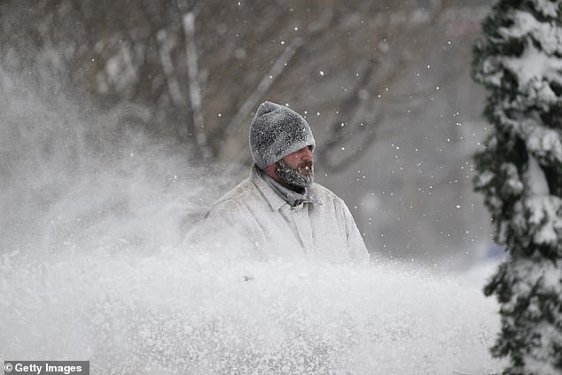
The storm will cause an outbreak in the Arctic, which could drop temperatures as heavy snow and ice create slippery travel conditions, drop tree branches and cause power outages
The ice risk from this storm will also be significant and impact a wide area from Wichita, Kansas to Roanoke, Virginia.
Heavy icing could impact communities from Springfield, Missouri to Lexington, Kentucky, with the most severe icing in cities such as Paducah and Joplin.
Much of eastern Kentucky will likely see up to a half inch of ice.
“Ice storms like this have been known to cause power outages over quite a large area,” DePodwin said.
‘Now is certainly the time to stock up. If you have a generator, make sure you know how to operate it, make sure it’s not in a place where it’s going to blow into your house.”
The ice and snow aren’t going anywhere anytime soon. In the wake of this storm, a mass of dangerously cold air will move into the region, and communities could be without electricity for days.
This could lead to a dire need for shelters to be set up to accommodate the affected population, AccuWeather senior meteorologist Courtney Travis reported.
As for the Northeast, the storm will remain largely south of New York City. But plowable snow is expected to accumulate in Washington DC, Baltimore and Philadelphia, with some sleet in between.
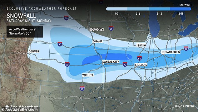
Snow could fall as far south as Oklahoma, and plowable accumulation will extend 1,000 miles from central Nebraska to Ohio through early Monday.
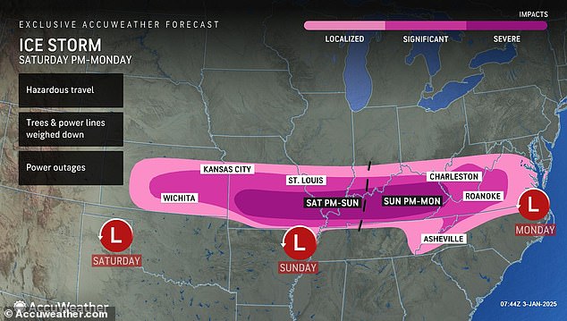
The ice risk from this storm will also be significant and impact a wide area from Wichita, Kansas to Roanoke, Virginia.
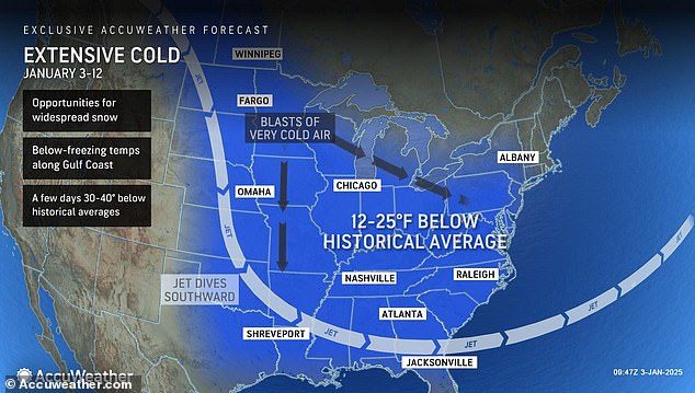
The cold temperatures expected to persist after this storm could lead to more winter storms in the eastern U.S. through mid-January
“The western suburbs of Baltimore and Washington DC could see nearly half a foot of snowfall by the end of the storm,” said AccuWeather meteorologist Brandon Buckingham.
Higher elevations in West Virginia and Western Maryland could see accumulations of up to 15 inches.
Travel conditions in the affected area could become treacherous Sunday night through Monday.
Sleet and freezing rain will also have a major impact, especially near the Appalachians.
Late Sunday night into Monday, ice may extend as far as the Virginia coast before the storm moves offshore.
Meanwhile, southern states should brace for rain, thunderstorms and the risk of several tornadoes this weekend as cold air in the Plains collides with warm, wet air from the Gulf of Mexico.
“A line of thunderstorms is expected to develop across eastern Texas Sunday afternoon and strengthen through Sunday night as they move into Louisiana, Arkansas, Mississippi and Alabama,” said AccuWeather meteorologist Gwen Fieweger.
Six to 12 tornadoes are also possible for this region during the day Sunday through Sunday night, DePodwin warned.
Strong winds, hail and flooding are possible along the Interstate 10 and 20 corridors.
The cold temperatures expected to persist after this storm could lead to more winter storms in the eastern US through mid-January.
