Urgent warning in three states after ‘bomb cyclone’ expected to bring ‘life-threatening’ hurricane conditions
An urgent weather warning has been issued for three west coast states after a bomb cyclone is expected to bring hurricane conditions to the region.
The National Weather Service (NWS) warned residents of Northern California, Oregon and Washington this week of possible hurricane force winds, catastrophic flooding and several feet of snow at high elevations.
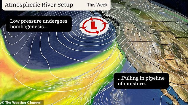
Meteorologist Ryan Maue said the central pressure of this bomb cyclone will drop nearly 70 millibars in 24 hours, reaching pressure levels comparable to a Category 4 hurricane.
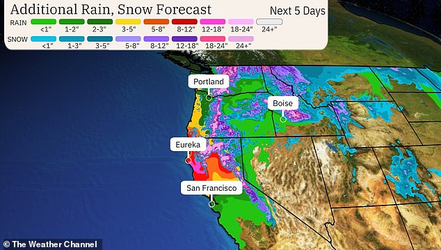
This super-charged storm will bring winds of up to 75 miles per hour and bring a Category 5 atmospheric river onto land, dumping up to 20 inches of rain in certain areas.
An atmospheric river is a long and narrow region in the atmosphere that transports heat and moisture from the tropics to the Earth’s poles. A Category 5 is exceptionally dangerous and causes intense storm effects on land.
Storm impacts are expected to begin Tuesday afternoon and last throughout the week, possibly into the weekend.
Americans living in these areas are advised to seek shelter in an interior room on the lowest floor of a sturdy building and avoid cars and mobile homes.
The bomb cyclone enters California on Tuesday, the photo shows a bomb cyclone that hit the west coast last year

A bomb cyclone is expected to draw an atmospheric river into Oregon, Washington and Northern California this week, hitting the West Coast with heavy rain and snow
The NWS forecast that Northern California and Southwestern Oregon will see the highest precipitation totals, potentially leading to flooding, landslides and mudslides.
As these storm systems move toward the West Coast, Washington, Oregon and California can expect at least six inches of rain, with more than eight inches possible in the mountains.
The flood of moisture flowing into the mountains could also drop several feet of snow from the higher elevations of the Cascades southward to the Siskiyou Mountains of Northern California. This may have consequences for traveling with some passes.
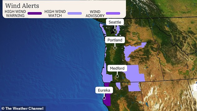
High winds should pick up Tuesday and continue into early Wednesday, with coastal areas of Northern California, Oregon and Washington possibly experiencing wind gusts in excess of 60 to 75 miles per hour. Power outages and fallen trees are expected.
Bomb cyclones form when a mid-latitude storm rapidly intensifies over a 24-hour period.
Intensification essentially means a drop in pressure, and storms must drop at least 24 millibars within a 24-hour period to be considered a bomb cyclone.
It is rare for a storm to lose 70 millibars of pressure so quickly.
By comparison, Hurricane Milton – which quickly strengthened from a Category 1 hurricane to a Category 5 hurricane – lost 84 millibars of pressure in 24 hours.

Storm impacts are expected to begin Tuesday afternoon and last throughout the week, possibly into the weekend

High winds should pick up Tuesday and continue into early Wednesday, with coastal areas of Northern California, Oregon and Washington likely to see wind gusts in excess of 60 to 75 miles per hour.
Maue added that the “mega” bomb cyclone and “climate-driven” atmospheric river will dump eight trillion gallons of precipitation in California, five trillion in Oregon, three trillion in Washington and 2.5 trillion in Idaho – a total of nearly 20 trillion gallons in this four areas. states.
Areas affected by burns, or charred, barren swaths of land left by wildfires, will be particularly susceptible to flooding.
That’s because burned soil can be just as water-resistant as pavement, according to the National Oceanic and Atmospheric Administration (NOAA).
Mudslides and rockslides are also more likely in areas recently affected by wildfires because the loss of trees, vegetation and their roots makes soil unstable and easily eroded.
On Tuesday afternoon, meteorologists predict heavy precipitation and strong winds will move toward the west coast as the bomb cyclone and atmospheric river approach the coast. WashingtonPost forecaster Ian Livingston reported.
Current forecasts focus on storm conditions from Vancouver Island, Canada, to around the Oregon-California border on Tuesday evening.
“Heading into Wednesday, the atmospheric river will likely slowly shift its focus southward, from southern Oregon to northern California,” Livingston reported.
By the end of the week and into the weekend, high-altitude rain and snow could shift into central or southern California, he added.
Extreme storm systems like this bomb cyclone are likely fueled by human-induced climate change in a number of ways, according to the Union of Concerned Scientists.
First, rising ocean temperatures are creating a greater contrast between temperatures over land and the temperature of Arctic air moving south. Storms feed on this ever-widening difference.
In addition, increasing evaporation from land, caused by rising global temperatures, is pumping the atmosphere full of water vapor. When that vapor condenses into clouds, it releases latent heat, which storms use as fuel.
Increased water vapor also provides more moisture for storms, resulting in more frequent heavy precipitation events.
Climate change is also increasing the number of days the western US will experience atmospheric rivers, according to the US Department of Agriculture.
And as warming air and ocean temperatures provide more fuel to make the rivers in the atmosphere bigger and stronger, they will also become more dangerous.
