Potential hurricane ‘Nadine’ is on a path to hit Florida in Milton’s wake
The US National Hurricane Center has identified a potential developing storm named ‘Nadine’ that will emerge just after the deadly approaching Category 5 Hurricane Milton.
The current “non-tropical area of low pressure,” NHC officials noted, is currently producing “gale-force winds” northeast of the Bahamas at a speed of 15 miles per hour.
Right now, this weather front has a 20 percent chance of becoming a tropical storm and could develop into a stronger hurricane storm before Wednesday evening – just as Milton is barreling across Florida.
NHC officials described Hurricane Milton itself as “potentially catastrophic” for Florida’s western coastal communities – a clear indication that yet another storm would soon cause unprecedented damage.
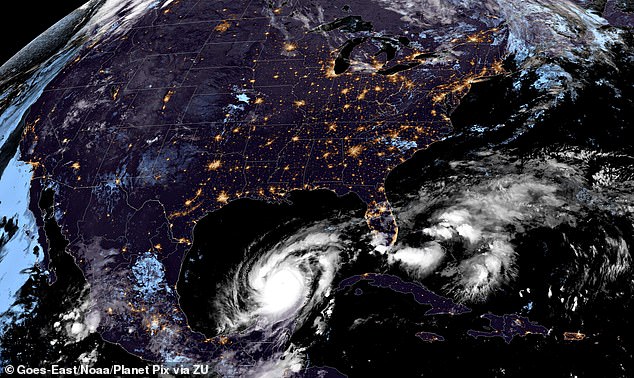
The US National Hurricane Center has identified a potential storm (in yellow above) emerging on the heels of deadly Category 5 Hurricane Milton. Currently, this weather front has a 20 percent chance of becoming a tropical storm or worse, who would be given the name ‘Nadine’.
Fortunately after Wednesday evening, said NHC Hurricane Specialist Andrew Hagenthe percentage chance that these storm force winds will culminate in a still hypothetical Hurricane Nadine will probably decrease dramatically.
“Higher level winds are likely to increase Wednesday night, which should end any chances for further development,” the NHC’s longtime maritime forecaster wrote in its advisory Tuesday.
According to the National Oceanic and Atmospheric Administration, hurricanes typically develop from tropical waves that combine with warm ocean water.
Thunderstorms and other atmospheric turbulence can help push a storm front to gather hurricane force, while warmer ocean air rises in these storm clouds, creating an area of low pressure below.
A hurricane’s maximum sustained wind speed, defined as the highest one-minute average wind speed at a given time, defines the boundary between these powerful storms and smaller tropical cyclones.
Hurricanes are defined as anything traveling at 75 miles per hour or higher.
A tropical cyclone is defined by maximum sustained wind speeds between 60 and 120 km per hour.
NHC described Hurricane Milton as “potentially catastrophic” for Florida’s western coastal communities — with trackers predicting Milton will plow northeast before turning sharply east toward Tampa.
Tampa Bay and surrounding communities are preparing for storm surges of up to 15 feet high that will cause flooding inland as residents try to flee amid traffic congestion.

Hurricane Milton, currently a catastrophic Category 4 hurricane with winds of 155 miles per hour, continues to rage across the Gulf of Mexico on its way to Florida, shown on the GOES-East satellite at 10:09 GMT, October 8, 2024
Across Florida counties caught in Milton’s northeastern path, rainfall is expected to reach two to four inches, with some regions likely to see as much as three to six inches.
These heavy rains are expected to cause flash flooding, slow and more persistent ‘surface’ flooding, overwhelmed storm drainage systems and ‘moderate to major river flooding’, the World Meteorological Organization said.
Milton stunned forecasters with its ability to go from a tropical depression or cyclone – with no more than 60 km/h winds – to a potentially record-breaking and deadly Category 5 hurricane in less than three days.
The worst impact of Hurricane Milton is forecast to continue into the early morning hours on Thursday, with the eye of the storm barreling through central Florida before passing over the East Coast sometime after 5 a.m. Eastern.
More than a million people have been told to evacuate Florida, the largest in seven years, after about seven million people were advised to leave in 2017 as Hurricane Irma ripped through the state.
Florida residents seeking assistance are urged to call the State Assistance Information Line (SAIL) at 1-800-342-3557 and/or the FEMA Helpline at 1-800-621-3362.
