Models put Florida on storm watch that could reach hurricane status
All eyes are on Florida after new hurricane models showed a storm brewing in the Caribbean is likely to hit the state next week.
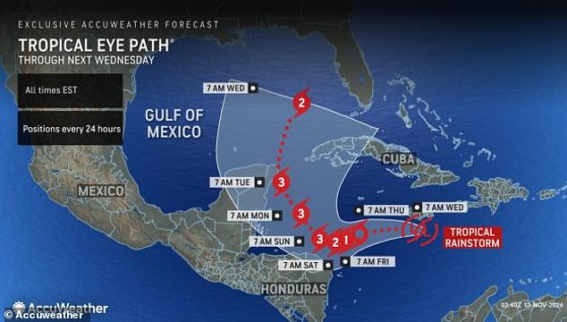
Sara, currently a tropical rain storm, will gain strength as it gets closer to the Gulf of Mexico, where it will travel between Cuba and Mexico on Monday before turning sharply north the next day.
The system could evolve into a hurricane by 7:00 PM ET on Thursday, reach Category 3 status two days later and reach Florida next Wednesday.
Meteorologists warned that Hurricane Sara would bring significant downpours, leading to flash flooding and strong wind gusts that could also pose a significant risk to lives and property.
AccuWeather predicted the storm’s track would produce fuel to become a potentially significant hurricane, impacting the Florida Keys and the southern part of the Florida Peninsula.’
The National Hurricane Center (NHC) is also monitoring Sara and reported on Wednesday that there is a 90 percent chance that it will become a low-pressure area with winds of up to 62 kilometers per hour within the next 48 hours.
“An Air Force Hurricane Hunter aircraft will investigate this system later today,” the service said.
Meteorologists are warning all residents of the central and eastern Gulf Coast to closely monitor the storm’s progress, noting that it is still too early to determine where the storm will end up.
Sara is currently a tropical rain storm in the Caribbean, but experts say it could develop into a Category 3 hurricane next week

AccueWeather revealed that Sara could reach Florida next Wednesday
AccuWeather meteorologist Alex DaSilva said, “There are multiple scenarios with this feature in the Caribbean related to the speed of development and early mapping that could impact land areas with landfall and later direct impacts.
“Not only is there a good chance this will become a hurricane by the end of this week, but it could become a major hurricane very quickly – this weekend.”
The NHC reported that Sara will steadily intensify as it “continues to produce a large area of showers and thunderstorms” in the Caribbean Sea.
Experts say areas in South Florida are likely to see several inches of rain, which could cause localized flooding next week.
The Caribbean Sea has been a hotspot for tropical storm and hurricane development this season due to warmer-than-average temperatures extending 300 to 400 feet below the ocean’s surface.
“This could act as rocket fuel for developing tropical storms or hurricanes,” DaSilva says.

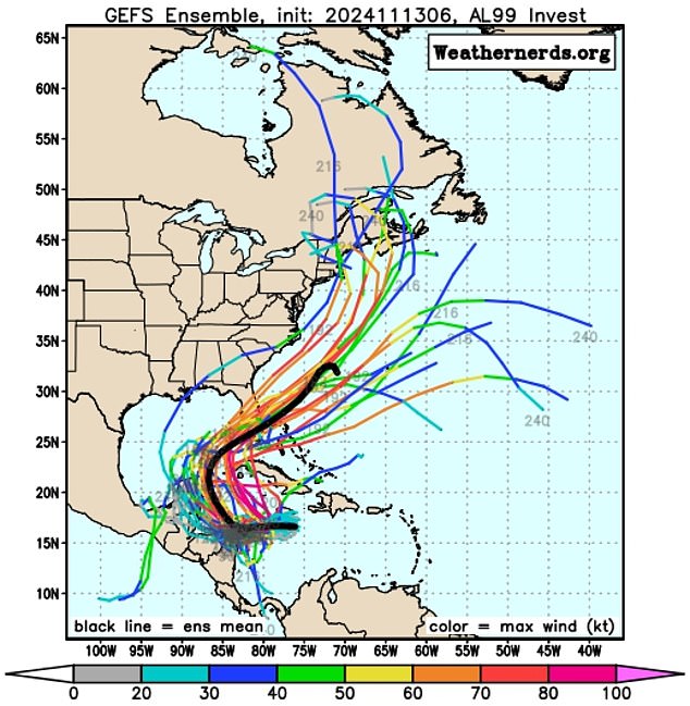
Meteorologists are monitoring several scenarios of the storm’s path, but AccuWeather noted that one certainly shows Sara hitting “significant impacts” in Florida next week.
A combination of warm water and little wind The Gulf of Mexico creates the perfect storm for a rapidly developing weather event.
And on top of these facts, Sara will likely follow the same path as Hurricane Rafael, collecting the remains as fuel.
The storm could take advantage of “some unusually favorable late-season conditions to strengthen early next week,” Michael Lowry, a hurricane specialist and storm surge expert at WPLG-TV, wrote on his blog.
Meteorologists are monitoring several scenarios of the storm’s path, but AccuWeather noted that one certainly shows Sara will hit Florida with “significant impacts” next week.
That means the Sunshine State will experience a fourth hurricane in the 2024 season.
“Should the event become a hurricane, it would be the twelfth of the season, which is a testament to the strong nature of the season, with the historical average being seven hurricanes,” DaSilva said.
However, other forecasts show a path to Central America or southeastern Mexico later this week and next week.
This potential path shows Sarah decreasing over the region or possibly beginning a turn toward the Gulf of Mexico and losing wind intensity, meaning it “may not have time to regain hurricane strength before approaching the Florida Peninsula.”
