Interactive map reveals deadly path of winter storm Blair as 60million are placed under dangerous weather alert
An interactive map shows how Winter Storm Blair will hit the eastern US this week.
More than 60 million people are under severe weather warnings, including in the cities of Baltimore, Cincinnati, Indianapolis, Louisville, Kentucky and Washington DC.
Blair is currently tracking eastward into the Appalachians and the mid-Atlantic, with very heavy snow expected through Monday.
Heavy snow, icing and high winds will create travel chaos from the Ohio Valley to the mid-Atlantic, prompting schools and government buildings to close their doors.
At least three people in Virginia and Kansas were killed Monday morning in traffic accidents caused by winter storm Blair.
In affected areas, ‘people should consider postponing all travel. Motorists should use extreme caution if travel is absolutely necessary,” the National Weather Service (NWS) warned.
Several states directly in the storm’s path are currently experiencing widespread power outages, with more than 350,000 customers affected in Missouri, Illinois, Indiana, Kentucky, Virginia and West Virginia, according to figures. poweroutage.us.
Another 10,600 are without electricity in Texas, which is not in the storm’s direct path but is still buffeted by winds of up to 50 miles per hour and below-average temperatures from Blair.
Southeastern states will also be affected as warm air from the Gulf of Mexico collides with the Blair cold front.
Strong to severe thunderstorms will develop across parts of the region on Monday, battering states with high-speed winds, isolated tornadoes, frequent lightning and possibly hail.
At least three people died in car accidents during the storm. The photo shows vehicles braving Blair in Ohio
The system will produce 6 to 12 inches of snow in the mid-Atlantic region, including the Washington, D.C., metro area, the NWS said in a 2:50 a.m. ET report. update.
The storm hit the Plains and the Midwest this weekend, bringing the heaviest snowfall in years in some areas.
Another two to four inches of snow will fall in parts of the Ohio Valley and central Appalachians, where travel disruptions will continue, the agency added.
On top of the snow, the eastern two-thirds of the U.S. will experience dangerous, frigid cold and wind chills starting Monday, with temperatures 12 to 25 degrees Fahrenheit below normal.
The storm is wreaking havoc on the country’s passenger railways, with more than 20 cancellations on Sunday and more than 40 scheduled for Monday and Tuesday.
Nearly 1,500 flights were canceled and another 740 delayed across the country on Monday morning, according to the tracking platform. Flight conscious.
Ronald Reagan Washington National Airport in Arlington, Virginia canceled 426 flights on Monday, about half of its total daily flights.
The storm is wreaking havoc across the Ohio Valley as it moves east from the Midwest.
School closures are expected to be widespread Monday as districts in Indiana, Virginia, Kentucky, Missouri and Kansas began announcing cancellations and delays Sunday afternoon.
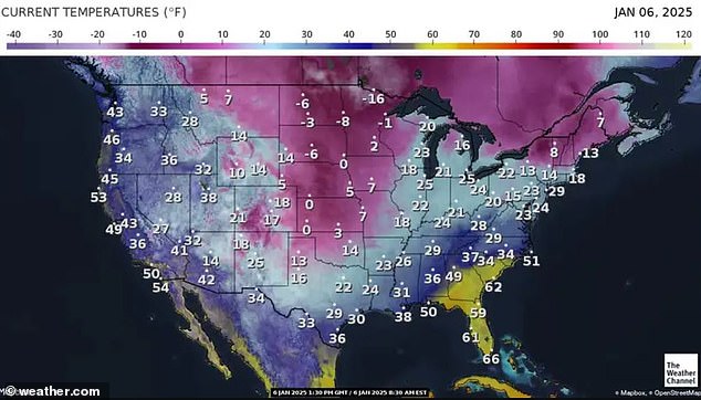
The eastern two-thirds of the U.S. will experience dangerous, frigid cold and wind chills starting Monday, with temperatures 12 to 25 degrees Fahrenheit below normal
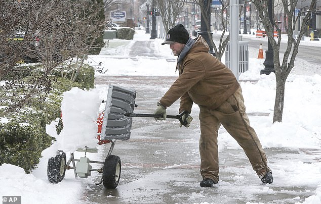
Owensboro, Kentucky received heavy snowfall as Winter Storm Blair barreled through the Ohio Valley
About four inches of snow fell across Kansas, with as much as 18 inches — the maximum reported for this storm so far — in Chapman and St. George.
On Sunday, Kansas City, Missouri saw its heaviest snowstorm since February 1993, accumulating 14 inches.
So far, the highest snowfall total for this state is 18 inches in three different northeastern locations.
A record eight inches of snow fell at Cincinnati/Northern Kentucky International Airport on Sunday, leading to dozens of flight cancellations that continued into Monday.
Another inch of snow was expected Monday in the Cincinnati region, where car and truck crashes are closing at least two major routes into downtown.
In Indiana, snow completely covered parts of Interstate 64, Interstate 69 and U.S. Route 41, prompting Indiana State Police to urge motorists to stay off the roads as crews worked to keep up.
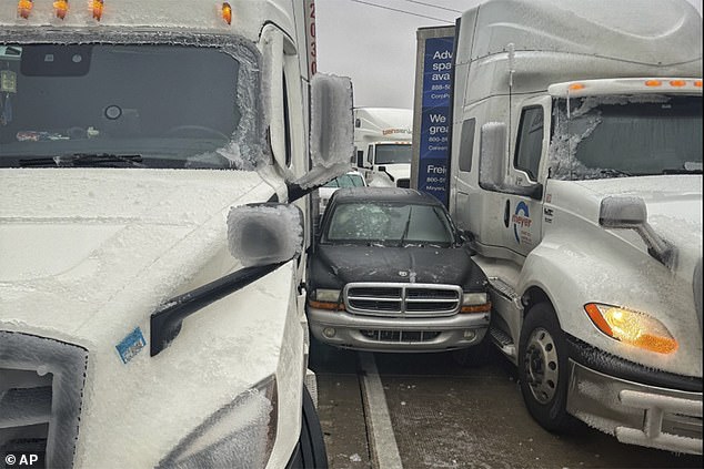
Salina, Kansas: A photo released by Kansas Highway Patrol shows a car stuck between two trucks due to icy weather on January 4
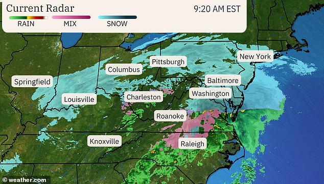
As of 9:20 a.m. ET Monday morning, Winter Storm Blair moved toward the mid-Atlantic states, bringing heavy snow
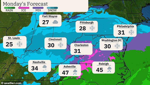
Snow, rain and a wintry mix will continue to fall along the East Coast through Monday
In Kentucky, Louisville recorded 22.7 inches of snow on Sunday, setting a new record for highest snowfall and breaking the previous record of 7 inches set in 1910.
At least 600 motorists were stranded in Missouri last weekend, authorities said.
Hundreds of car crashes were reported in Virginia, Indiana, Kansas and Kentucky, where a state trooper was treated for non-life-threatening injuries after his patrol car was struck.
In Virginia alone, more than 200 vehicle crashes occurred in a 12-hour period between 4 p.m. Sunday and 4 a.m. Monday, according to state police, one of which was fatal.
The 32-year-old man died around midnight in Wakefield, south of Richmond, after his truck left the road and hit a tree.
Police say he was driving too fast for road conditions and was not wearing a seat belt, while alcohol appears to be a factor.
Two others died in a single-vehicle crash in Sedgwick County, Kansas. The accident happened on Sunday at 8:40 p.m.
Several inches of snow have already fallen in the Mid-Atlantic states, and another inch to an inch could fall by the end of the day as the storm marches further east.
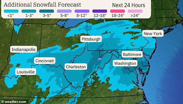
Over the next 24 hours, Blair will deliver 2 to 6 inches of additional snow to cities such as Indianapolis, Charleston and Washington DC
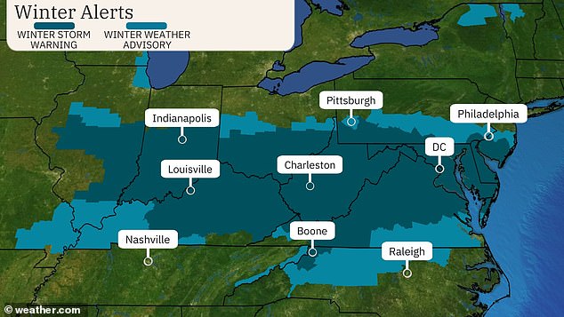
Much of the eastern US is under winter weather warnings as winter storm Blair heads towards the Atlantic coast
Baltimore and Washington DC reported both moderate to heavy snow and poor visibility early this morning.
Up to six inches of snow has fallen in parts of the DC metro area, with some sleet starting to arrive.
But D.C., Maryland and Virginia can expect a respite from severe winter weather in the coming hours, with radar showing a “dry slot” approaching this area, The Weather Channel reported.
Winter Storm Blair will remain largely south of the Northeast, but will have some impact on the tri-state area and the Philadelphia metro area.
A weather warning is in effect throughout South Jersey, with Ocean County likely to see the highest accumulation of two to six inches of snow on Monday. The rest of the state could see one to five inches.
New York’s Hudson Valley, Long Island and Connecticut state can also expect a light dust cloud of up to two inches.
Overall, NYC is expected to receive one to two inches. The highest totals are most likely to be found on Staten Island, along with the southern parts of Brooklyn and Queens.
Lower Chester counties in Pennsylvania are under a winter storm warning, including Philadelphia, where two to four inches are expected to accumulate Monday.
In the Southeast, Blair’s impact will look very different, with severe thunderstorms, scattered tornadoes and high winds hitting states along the Gulf Coast.
The NWS issued cold weather advisories for much of Texas, including Dallas and Fort Worth, southern Louisiana, Mississippi, Alabama and the Florida Panhandle into central Florida.
Freeze warnings have been issued for southeastern Texas and southwestern Louisiana, as well as northeastern Florida and southeastern Georgia.
The storm will continue to batter the eastern U.S. through Tuesday, when it is expected to move toward the Atlantic Ocean.
