Hiker captures mesmerising footage of a rare ‘ice pancake’ in the Scottish Highlands 

>

Talk about an ice view! Hiker captures mesmerising footage of a rare frozen ‘pancake’ in the Scottish Highlands

A hiker captured the incredibly rare phenomenon of an ‘ice pancake’ on a mountain walk in the Scottish Highlands.

The circular sheet of ice is seen in a glen on the mountain of Beinn Bhuidhe, which is south of Lochan Shira, and north of Achadunan.

Dan Brown, 32, from Dunoon was hiking up the Munro when he came across the rare sight with his father.

He said: ‘I was hiking Beinn Bhuidhe, a Munro at the head of Loch Fyne, with my father.
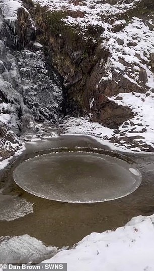
The circular sheet of ice is seen in a glen on the mountain of Beinn Bhuidhe, which is south of Lochan Shira, and north of Achadunan

A hiker captured the incredibly rare phenomenon of an ‘ice pancake’ on a mountain walk in the Scottish Highlands

How do ice pancakes form? 

Ice pancakes can form in one of two distinct ways, both of which require very specific conditions. 

In oceans, seas and lakes, ice pancakes form when waves cause forming pieces of ice to knock against each other, rounding their edges as they freeze and grow. 
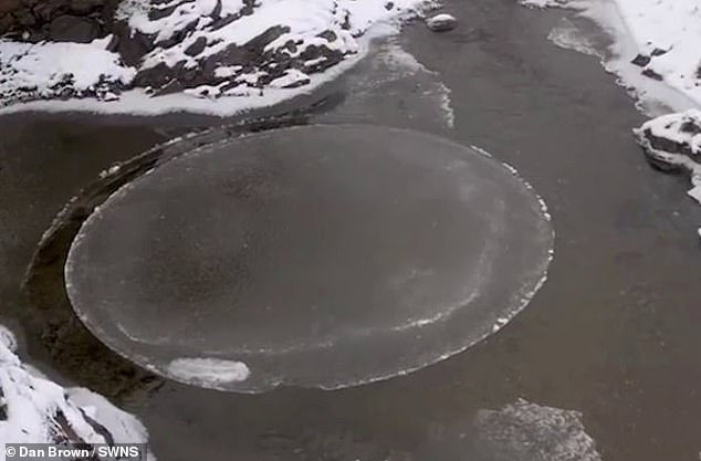
‘Small rims are created on the edges as the knocking causes splashing water to freeze and join the rim,’ the Met Office explained. 

Alternatively, ice pancakes can form when foam on a river begins to freeze. 

The foam joins together, and as it is sucked into an eddy, a circular shape begins to form. 

‘As other bits of frozen foam and ice hit the forming disc they freeze to it and increase its size,’ the Met Office added. 

While ice pancakes often look like solid discs, they are usually quite slushy and easily break apart when lifted up. 

‘However, when given the conditions to consolidate, ice pancakes can end up binding with each other to form sheet ice and in rougher conditions waves can move these sheets of ice causing them to bend and crack to create ice ridges,’ the Met Office concluded. 

‘We’d taken mountain bikes with us and, for the best part, had been carrying them up a hydro track.

‘Visibility wasn’t great, but after about an hour-and-a-half the snow stopped and cloud cover started to clear.

‘We took a break to fill our water bottles from the burn by the track – that’s when we noticed the ice disk slowly spinning at the foot of a small waterfall.’

Both Dan and his father had never seen or experienced an ice disk in the flesh and were taken aback.

He added: ‘Neither of us had ever seen anything like it, a perfect circle of ice slowly rotating in the water, so we thought it must be a rare occurrence and took some photographs and videos.

‘We assumed at the time that it was caused by the flow of the waterfall meeting the current of the burn, it wasn’t until afterwards I read about ice disks and realised this was what we’d witnessed.

‘We hadn’t encountered anyone else on the hike, it felt like we were the only people for miles around.

‘So then to happen across something so serene and perfectly formed, it felt surreal.’

Ice pancakes can range in size from 7.8 inches (20cm) to 78 inches (200cm) wide, and are ‘relatively rare’, according to the Met Office

‘They are most frequently seen in the Baltic Sea and around Antarctica but also form relatively frequently on the Great Lakes of the United States and Canada,’ it explained.

Ice pancakes can form in one of two distinct ways, both of which require very specific conditions. 

In oceans, seas and lakes, ice pancakes form when waves cause forming pieces of ice to knock against each other, rounding their edges as they freeze and grow. 

Ice pancakes can range in size from 7.8 inches (20cm) to 78 inches (200cm) wide, and are 'relatively rare', according to the Met Office

Ice pancakes can range in size from 7.8 inches (20cm) to 78 inches (200cm) wide, and are ‘relatively rare’, according to the Met Office

‘Small rims are created on the edges as the knocking causes splashing water to freeze and join the rim,’ the Met Office explained. 

Alternatively, ice pancakes can form when foam on a river begins to freeze. 

The foam joins together, and as it is sucked into an eddy (a swirling current of water), a circular shape begins to form. 

‘As other bits of frozen foam and ice hit the forming disc they freeze to it and increase its size,’ the Met Office added. 

While ice pancakes often look like solid discs, they are usually quite slushy and easily break apart when lifted up. 

‘However, when given the conditions to consolidate, ice pancakes can end up binding with each other to form sheet ice and in rougher conditions waves can move these sheets of ice causing them to bend and crack to create ice ridges,’ the Met Office concluded. 
Why IS the British weather so changeable? UK is ‘unique’ because FIVE air masses battle for supremacy above it

Warm and sunny one minute, rain the next, sometimes the British weather can be so wildly changeable it’s difficult to keep up. 

MailOnline spoke to several meteorologists about what makes the UK’s weather so ‘unique’, as one put it, and whether any other country in the world compares.

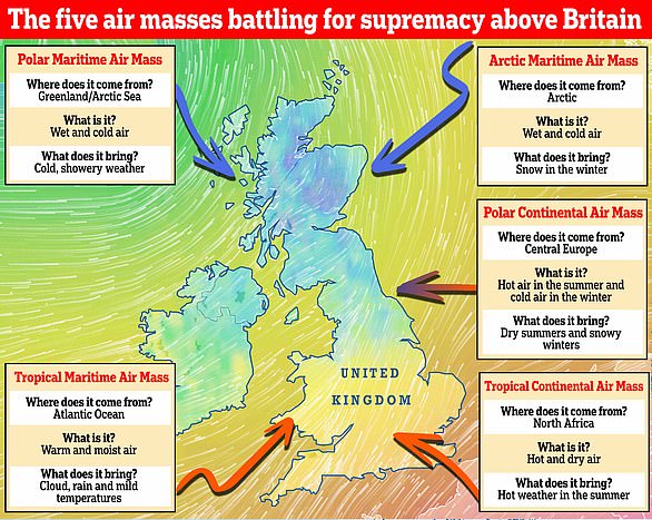
At the heart of it are five main air masses that each have similar temperature and moisture properties. They battle for supremacy above Britain and can spark an extraordinary mix of atmospheric conditions when they clash. 

Which weather will we get? There are five main air masses that battle it out above Britain. They include the Polar Maritime, Arctic Maritime, Polar Continental, Tropical Continental and Tropical Maritime. A sixth air mass, known as the returning Polar Maritime, also affects the UK

Which weather will we get? There are five main air masses that battle it out above Britain. They include the Polar Maritime, Arctic Maritime, Polar Continental, Tropical Continental and Tropical Maritime. A sixth air mass, known as the returning Polar Maritime, also affects the UK

‘The UK doesn’t have its own weather,’ said Met Office forecaster Aidan McGivern, ‘it borrows it from elsewhere.’

‘That is what the air masses are — large bodies of air that come from other places.’ 

Professor Liz Bentley, CEO of the Royal Meteorological Society, said: ‘When two air masses are next to each other that is when we get dramatic weather conditions.

‘Air masses are dependent on wind direction; if coming from the continent they are continental, from the north they are polar, from the ocean it’s maritime and from the south they’re tropical.’  

They include the Polar Maritime, Arctic Maritime, Polar Continental, Tropical Continental and Tropical Maritime. A sixth air mass, known as the returning Polar Maritime, is also seen above Britain and is a variation of the Polar Maritime.

Each air mass brings a different type of weather, but as they meet and battle it out, it’s the one that wins which dictates if we get warm sunshine, freezing rain or a spectacular thunderstorm.

Professor Bentley added: ‘Although all the air masses have a role to play, the prevailing wind direction for us is westerly so we tend to see more coming from the Atlantic.

‘In the winter, air from the continent is very cold. That’s why we had the Beast from the East in 2018 — because freezing air was coming from Siberia.

‘However, in the summer, when the Tropical Continental air mass is more common, the air is warm because it’s coming from a very hot continent, so you’re likely to get heatwaves.’