Sydney, Melbourne, Brisbane weather: Australia records its second hottest year on record – with a scorching heatwave to blast the country
Australia experienced its second warmest year in 2024 since reliable measurements began in 1910 – and the first week of 2025 doesn’t look any cooler.
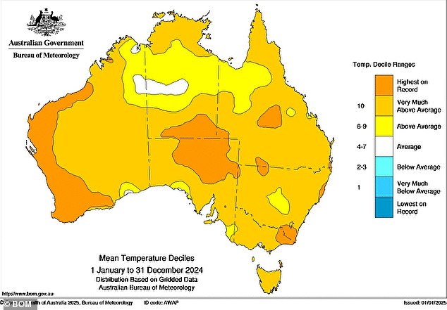
Australia’s average temperature in 2024 was 1.46 degrees Celsius above the average from 1961 to 1990. This is the 24th year in a row that the country has failed to record a below-average average temperature.
Last year is only second to 2019 as the warmest year since records began, when temperatures were 1.51 degrees Celsius above average.
“What makes 2024 exceptional is that, unlike 2019, Australia received quite a bit of rain, with 2024 being the country’s wettest year since 2011 and the eighth wettest year in records going back to 1900,” said Ben Domensino of Weatherzone.
‘Historically, Australia’s warmest years have coincided with periods of low rainfall and drought. Although some parts of southern and western Australia experienced moderate rainfall in 2024, most of the country was abnormally wet.’
The highest temperature, 49.9 degrees Celsius, was recorded at Carnarvon Airport on February 18 – equal to the eighth highest temperature ever recorded in Australia.
The country’s lowest temperature was in Liawenee, Tasmania, on July 4 at -13.5 degrees Celsius, while the coolest temperature on the mainland was -11.1 degrees Celsius on July 3 at Thredbo.
Tully in north Queensland took home the prize for highest rainfall, recording 488mm during the 24 hours ending at 9am on February 24.
Australia starts 2025 with a heatwave after having its second warmest year in 2024 (photo, temperature forecast for Sunday afternoon)

Australia’s average temperature in 2024 was 1.46 degrees Celsius above that between 1961 and 1990, marking the 24th year in a row that the country has failed to record a below-average average temperature
While many Australians were expecting a cooler 2025, a heatwave will bring last year’s high temperatures into the new year.
The heat wave will affect large parts of the country, with temperatures in some areas 12 degrees Celsius higher than average.
According to the Bureau of Meteorology, severe to low heatwave conditions are forecast for parts of Queensland’s Cape York Peninsula, northwestern parts of the Northern Territory, parts of the southern interior in Western Australia and parts of western South Australia.
Low intensity heatwave conditions in parts of the ACT and central, northwestern and southern New South Wales, parts of northern and southwestern Queensland, parts of the Top End, much of eastern WA and parts of the Kimberley, the Pilbara and northwestern WA, parts of the Yorke Peninsula, the Eyre Peninsula and Kangaroo Island and eastern and southern SA, parts of eastern and central Victoria, and isolated areas in Tasmania.
Perth has already seen scorching conditions, with 38 degrees Celsius recorded on New Year’s Day.
It was the hottest start to the year in the city since 1997, with temperatures above 42 degrees Celsius.
Heatwave conditions are expected to worsen in eastern Australia as hot and dry air moves over South Africa and Victoria this weekend before reaching NSW on Sunday and Monday.

The highest temperature, 49.9 degrees Celsius, was recorded at Carnarvon Airport on February 18 (Photo: Average temperatures around Australia for 2024)
Sydney
Friday: Cloudy. There is some chance of showers in the morning and early afternoon. Light winds, east to northeast 15 to 20 km/h during the middle of the day, then light in the late evening. Min. 20. Max. 26.
Saturday: Sunny morning. In the far west there is a chance of a thunderstorm in the afternoon and evening. Light wind, moderate 15 to 25 km/h during the day, then light in the evening. Min. 20. Max. 29.
Sunday: Mostly sunny. Small chance of showers in the west, virtually zero elsewhere. There is a chance of a thunderstorm in the west in the afternoon and evening. Wind north to northeast 15 to 20 km/h, trending east to northeast 15 to 25 km/h during the day then light in the evening. Min. 21. Max. 32.
Melbourne
Friday: Sunny. Wind southeast to southwest 15 to 25 km/h, light in the late evening. Min. 12. Max. 29.
Saturday: Mostly sunny. Wind north to northwest 15 to 25 km/h, becoming west to northwest during the afternoon, then trending southeast to southwest 15 to 20 km/h during the evening. Min. 17. Max. 38.
Sunday: Cloudy. Small chance of showers, probably in the afternoon and evening. There is a chance of a thunderstorm over the nearby hills in the afternoon and evening. Light winds from north to northeast 15 to 25 km/h in the morning. Min. 21. Max. 34.

A heat wave will hit large parts of the country, with temperatures in some areas reaching 12 degrees Celsius above average
Brisbane
Friday: Partly cloudy. Moderate chance of showers, probably in the morning and afternoon. Light winds, moderate to 20 to 30 km/h in the morning, then light in the late evening. Min. 21. Max. 29.
Saturday: Partly cloudy. Moderate chance of showers, probably in the morning and afternoon. Light winds becoming east to southeast, 15 to 25 km/h, in the morning, then becoming light in the evening. Min. 21. Max. 29.
Sunday: Partly cloudy. Small chance of showers. Light winds, easterly at 15 to 20 km/h during the day, then light in the evening. Min. 21. Max. 29.
Perth
Friday: Cloudy morning, clear spells to a sunny afternoon. Wind south to southwest 20 to 30 km/h. Min. 17. Max. 28.
Saturday: Mostly sunny. Wind south to southeast 15 to 25 km/h, becoming south to southwest 20 to 30 km/h in the afternoon, then trending south to southeast 15 to 20 km/h in the evening. Min. 17. Max. 28.
Sunday: Sunny. Wind east to southeast 15 to 25 km/h, trending southeast to southwest in the afternoon then light in the evening. Min. 16. Max. 31.
Adelaide
Friday: Sunny. Wind northeast to southeast 15 to 20 km/h, trending northwest to southwest in the middle of the day, becoming light in the evening. Min. 15. Max. 35.
Saturday: Partly cloudy. Wind northwest to northeast 15 to 25 km/h, trending west to northwest during the day and shifting east to southeast 15 to 20 km/h in the evening. Min. 21. Max. 36.
Sunday: Partly cloudy. Small chance of showers, probably in the evening. Wind east 15 to 20 km/h, turning west 15 to 25 km/h in the morning and then southwest 20 to 30 km/h in the afternoon. Min. 23. Max. 33.
Hobart
Friday: Mostly sunny. Light winds, first southeasterly 15 to 20 km/h in the early afternoon, then light in the late evening. Min. 9. Max. 23.
Saturday: Mostly sunny. The wind is northwesterly, 15 to 20 km/h, turns southeasterly during the day and becomes light in the evening. Min. 13. Max. 29.
Sunday: Cloudy. Medium chance of showers. Light winds, southeasterly 15 to 20 km/h in the morning, then light in the evening. Min. 16. Max. 21.
Canberra
Friday: Partly cloudy. Small chance of showers. Wind southeast 15 to 20 km/h becoming light before sunrise, then becoming northeasterly to southeast 15 to 20 km/h in the evening. Min. 10. Max. 30.
Saturday: Partly cloudy. Small chance of showers. Chance of thunderstorms in the morning and afternoon. Light winds, west to northwest 15 to 20 km/h during the day, then light in the evening. Min. 13. Max. 34.
Sunday: Partly cloudy. Moderate chance of showers, probably in the morning and afternoon. Chance of thunderstorms in the afternoon and evening. Light winds, west to northwest 15 to 20 km/h during the day, then light in the afternoon. Min. 16. Max. 35.

Heatwave conditions are expected to worsen in eastern Australia as hot and dry air moves over South Africa and Victoria this weekend before reaching NSW on Sunday and Monday.
Darwin
Friday: Partly cloudy. High chance of showers, probably in the late morning and afternoon. The chance of thunder. Light wind. Min. 26. Max. 35.
Saturday: Partly cloudy. High chance of showers, probably in the morning and afternoon. The chance of thunder. Light wind. Min. 25. Max. 33.
Sunday: Partly cloudy. High chance of showers, probably in the afternoon. The chance of thunder. Light wind. Min. 25. Max. 33.
