Declassified US spy satellite images reveal a historic battlefield that ended in bloodbath 1,400 years ago
Declassified US spy satellite images from the 1970s have led archaeologists to the site of a historic battlefield that ended in carnage in Iraq 1,400 years ago.
They compared footage taken during the Cold War with the historical text of the Battle of al-Qadisiyah, finding the location about 20 miles (32 kilometers) south of Kufa in Najaf Governorate.
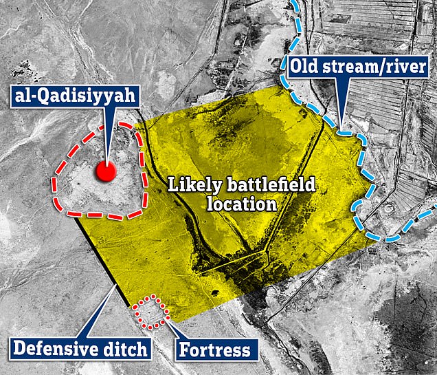
A six-foot-long structure was spotted in the black-and-white photos, matching ancient stories that led researchers to uncover a deep ditch, two forts and an ancient river that was once crossed by a Persian pride of elephants.
The research also revealed pottery shards consistent with the period in which the battle took place.
The site, in what was previously known as Mesopotamia, was where the Sassanid Persian and Arab armies fought in the Battle of al-Qadisiyah, ending Muslim rule.
The Sassanids lost over 20,000, while the Muslims lost over 10,000.
The battle took place around 637 AD. and was a crucial victory for the Arab Muslims in expanding Islam beyond Arabia.
Dr. William Deadman, archaeologist from Britain’s Durham University, said: ‘This discovery provides a geographical location and context for a struggle that is one of the foundational stories of Islam’s expansion into modern-day Iraq, Iran and beyond.’
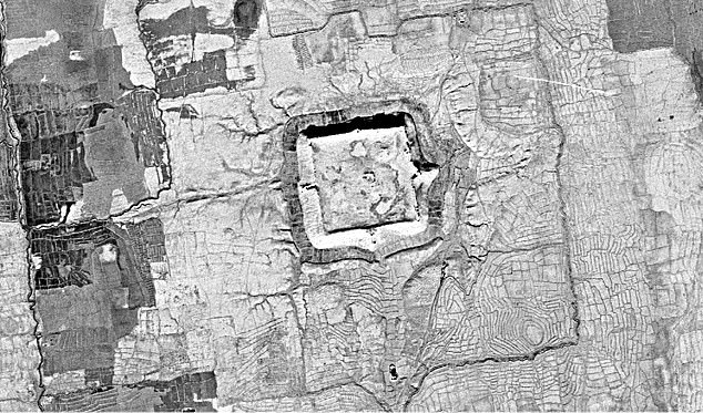
The image, taken in 1973, was released in 2022 for archaeological and historical research. Researchers used the photo and historical text to determine the location of the ancient battlefield
The image was captured in 1973 by the HEXAGON ‘Search & Spotter’ satellite, which was deployed over the Middle East during the Arab-Israeli war.
The US became heavily dependent on oil from the region, which increased during the conflicts.
After the Iraqis signed a treaty with the Soviets in April 1972, U.S. officials “particularly within the Central Intelligence Agency (CIA)” agreed that the threat from Baghdad deserved attention with the use of spy satellites.
The image used by the University of Durham, together with archaeologists from the University of Al-Qadisiyah, was released specifically for research in 2022.
The team stumbled upon the site while conducting a remote sensing survey to map the Darb Zubaydah (DZ), a pilgrimage route from Iraq’s Kufa to Mecca in Saudi Arabia, which was established more than 1,000 years ago.
They found that a site about 20 miles south of Kufa in Iraq’s southern Najaf province – a desert area with scattered plots of agricultural land – showed features that closely matched the description of the al-Qadisiyah battlefield as described in historical texts.
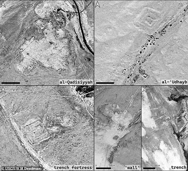
These included the double wall, possibly a canal, connecting a square fort on the desert edge and a large settlement associated with a linear fortification system on the edge of the floodplain.
During this investigation, two previously unlocated DZ intermediate stations, al-Qadisiyyah and al-‘Udhayb, were also identified.

The team identified two way stations, al-Qadisiyyah and al-‘Udhayb, previously known only through ancient texts

Pictured is a close-up of what appeared to be a hill in the photo, but was once a fortress used in battle
“These historic sites are best known from texts describing one of the most famous battles of the early Islamic conquests,” the team shared in the study published in the journal Antiquity.
The Sassanid dynasty ruled the region after it was founded in 224A, but became the last Persian imperial dynasty after the Muslim victory at the Battle of al-Qadisiyah.
They had a caste system with four classes: priests, warriors, secretaries and commoners.
The Arab army was part of the Rashidun Caliphate, which was led by the first four successors of the Islamic prophet Muhammad.
The group were excellent fighters and used shock troops, flanking maneuvers, mounted archery, sieges, reconnaissance, raids and horse breeding.
The rise of Islam and the Arab conquests, which aimed to expand the new Islamic Caliphate, led to conflict between the two nations.
“The Middle East has developed enormously in the last fifty years, both in agriculture and in urban areas,” said Dr. Deadman.
“Some of the distinguishing features of the Al-Qadisiyah site, such as a prominent trench, were ‘much more pristine and clear’ in the 1970s images.”

