Cyclone jasper update: When tropical storm will make landfall and Queensland areas impacted
Preparations are in full swing as Cyclone Jasper approaches the Queensland coast, bringing with it the threat of flash flooding, thunderstorms and gale-force winds.
The Bureau of Meteorology has forecast the storm to make landfall on Wednesday within a 400km coastline between Cooktown and Innisfail.
The system weakened to category one as it moved west towards the coast this weekend, but is expected to intensify again before making landfall as category two near Port Douglas, north of Cairns, on Wednesday afternoon.
When category two tropical cyclones make landfall, you can expect:
- Heavy wind speeds: Average wind speeds ranging from 89 to 117 km/h, accompanied by gusts of 125-164 km/h.
- Damage potential: Minor damage to houses and significant damage to signs, trees, caravans and certain crops.
- Risk of power outages: There is a risk of power outages due to the impact of the cyclone.
There remains a 'slim' chance that the cyclone could develop into a category three.
“If the system is slower and crosses the border on Wednesday or Thursday, there remains a small chance of a serious category three crossing,” the Bureau said.
Supermarket shelves in Cairns have been cleared of essentials such as bottled water and canned goods.
Cairns supermarket shelves have been cleared of essentials such as bottled water and canned goods, but some items are still available (pictured)

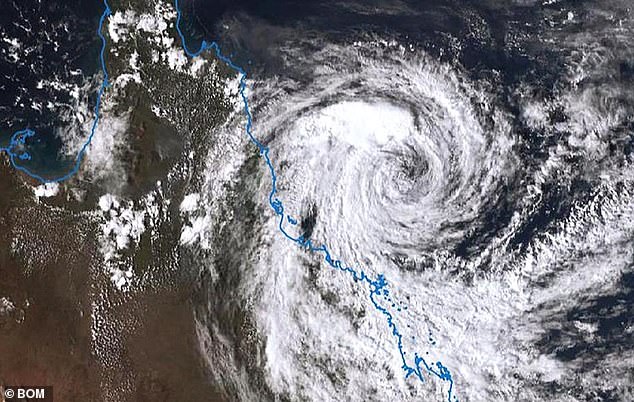
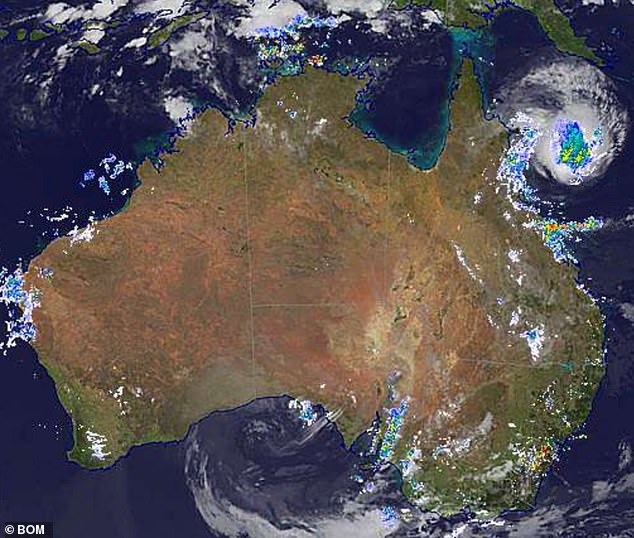
The Bureau of Meteorology has forecast that Cyclone Jasper (pictured) will make landfall within a 400km coastline between Cooktown and Innisfail on Wednesday.
Gale-force winds are expected to hit several communities beginning Tuesday. will affect residents of Wujai Wujai, Wonga, Port Douglas, Cairns, Babinda, Innisfail, Ravenshoe, Herberton, Atherton and Mareeba from early tomorrow morning.
Damaging winds of up to 120 kilometers per hour will also threaten coastal areas between Cape Flattery and Townsville, extending inland as far as Palmerville and Chillagoe.
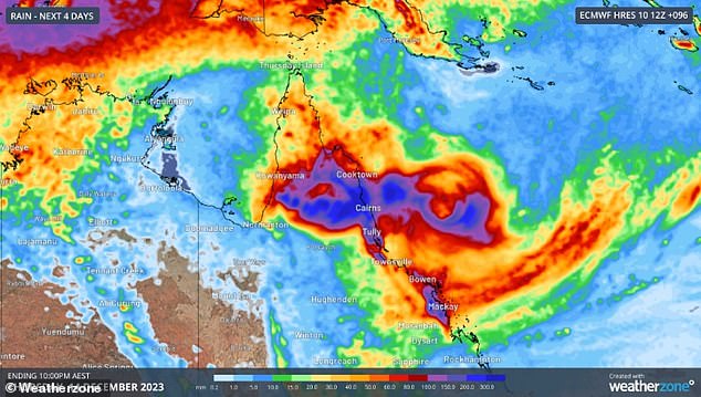
Heavy rain will fall between Cape Flattery and Cardwell on Wednesday, which could develop into flash flooding, with a total of more than 250mm over 24 hours.
Evacuation centers have been set up across the region, with Deputy Prime Minister Steven Miles warning of a significant risk of flash flooding when Jasper makes landfall.
“It will then spread across the Cape and affect some of the most vulnerable communities in Queensland,” he said.
Swiftwater rescue teams and additional police and force crews have been sent to the north of the state in anticipation of the wild weather.
Cairns District Acting Chief Disaster Inspector Sonia Smith has urged holidaymakers to travel north.
She urged motorists to stay aware of road closures and flash flood warnings.

There remains a 'slim' chance that the cyclone (pictured) could develop into a Category 3, prompting authorities to take significant precautions

Preparations are in full swing as Cyclone Jasper approaches the Queensland coast, bringing the threat of flash flooding, thunderstorms and strong winds

Late on Monday, Jasper was 425km east of Cairns and about 365km from Townsville, with winds of 85km/h and gusts of up to 120km/h
A cyclone watch zone currently extends inland and further north to Cape Melville.
Services in the region, including the ferry to the Daintree River, are suspended, with the Cairns harbor master ordering all vessels to be grounded.
“The potential for very strong winds, rising water levels and possible debris moving through the Daintree River would mean that operating the ferry would not be safe,” Douglas Shire Council said in a statement.
Not only will residents face dangerous winds before the storm hits, Jasper has already produced a storm surge affecting coastal areas between Cooktown and Townsville.
A storm surge or high tide occurs when coastal waters rise above the highest tidal levels due to a cyclone, creating 'tsunami-like waves' that travel inland.
'Large waves can cause minor flooding along the waterfront. “People living in areas likely to be affected by these floods should take steps to protect their property as much as possible and be prepared to assist their neighbors,” the agency said.
Those in the Cairns region have been told the storm surge could occur in any of the regions identified by the red, orange and yellow zones on the disaster warning map.
Port Douglas is also called the 'red zone' of a possible storm surge.
“Storm surge poses a threat to life and property,” said a warning on the Cairns Disaster Center Facebook page.
Residents have been told to prepare to isolate before Tuesday afternoon as the cyclone could flood roads, cutting people off from towns and cities.
“Most importantly, make sure that any things outside the house that could be blown into the air by the high winds, such as trampolines and furniture, all those things are put away and brought inside,” Cairns Mayor Terry James said in the Today show.
'It's important that you have your emergency kit ready with batteries, some batteries for your phone and enough food for five days.'
Late on Monday, Jasper was 425km east of Cairns and about 365km from Townsville, with winds of 85km/h and gusts of up to 120km/h.
