Hurricane watchers issue ‘advanced risk’ warning for storm Patty that could hit the US
Meteorologists are monitoring an area of potential tropical storm development in the Caribbean that could send another hurricane heading toward Florida.
According to AccuWeather, Tropical Storm Patty could form in the western and central part of the sea as early as next week, with a formation period from October 30 to November 2.
As the Atlantic Ocean approaches the final month of hurricane season, the risk of a tropical depression or storm development is currently “high” in this area, which is near where Tropical Storm Nadine formed last week.
“We suspect there will be another attempt to produce a tropical depression or tropical storm in the western Caribbean by the middle of next week,” said Bernie Rayno, AccuWeather’s chief on-air meteorologist.
“As a result, we have issued an advanced risk development zone.”
The exact path this storm could take remains unclear. But atmospheric conditions could be favorable for a path to Florida, said Alex DaSilva, AccuWeather’s chief meteorologist.
If Patty heads toward Florida, it would make landfall on the state’s west coast, which is still recovering from successive major hurricanes — Helene in September and Milton in October.
Meteorologists are monitoring an area of potential tropical storm development in the Caribbean that could send another hurricane heading toward Florida
The storm’s final path will be determined by the jet stream: the fast, narrow stream of air that flows from west to east and encircles the globe.
“As far as Florida is concerned, what would essentially have to happen is there would have to be some kind of dip in the jet stream for that storm to move north,” DaSilva shared. Newsweek.
‘It’s certainly possible for that to happen. There have been storms moving north toward the Florida peninsula during the month of November.”
Depending on atmospheric conditions, it is possible that potential Patty could move inland and impact the Carolinas, which are still reeling from the impact of Hurricane Helene.
The reason meteorologists keep a close eye on this area is because conditions are ripe for hurricane formation.
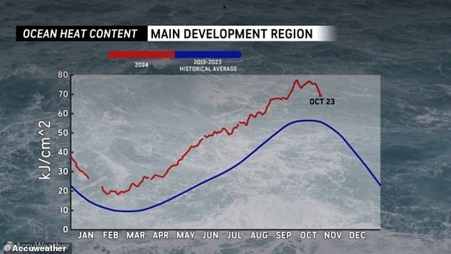
Water temperatures in the Caribbean are warm both at the surface and deep below, AccuWeather reported. This heat can fuel tropical storms.
“I know there will be showers and thunderstorms in this area next week. The question is wind shear,” Rayno said.
Wind shear is a change in wind speed and/or direction over a short distance. It can make or break a tropical storm depending on several factors, including whether the wind shear is vertical or horizontal and how strong it is.

Water temperatures in the Caribbean are warm both at the surface and deep below, AccuWeather reported. This heat can fuel tropical storms
On its possible impact on potential Tropical Storm Patty: “If there’s little wind shear, which we expect, I think we’ll have a tropical depression or storm,” Rayno said.
Additionally, this high risk of tropical storm formation is partly due to the Central American Gyre, a large, inflated area of low pressure that is more active at the beginning and end of the hurricane season.
When tropical storms form within this gyre, they can take longer to develop into a cyclone, resulting in days of stormy conditions and rough seas in the Caribbean before the storm is officially named, according to AccuWeather.
“From a climatological perspective, tropical storms that form in this area in late October and early November have a tendency to reach Central America or possibly north-northeast toward Cuba, Hispaniola and the Bahamas,” AccuWeather Senior Meteorologist Alex Sosnowski said.
“However, a track to Florida or the southeastern US mainland cannot be ruled out at this early stage,” he added.
Despite the concerns of meteorologists, the official forecast from the National Hurricane Center (NHC) shows that there is no threat of tropical storm formation in the Atlantic Ocean over the next seven days.
If Patty were to form, this storm would follow Hurricane Oscar, which made landfall in Cuba as a Category 1 storm and left at least six dead.
Tropical Storm Nadine, which formed near the high-risk area meteorologists are currently monitoring, made landfall in Belize before dissolving over Mexico and then transforming into Hurricane Kristy — all in just 72 hours.
This Category 5 storm is currently about 600 miles southwest of Mexico’s Baja California Peninsula and is moving west at a steady 16 mph (26 km/h) but is not expected to make landfall.
