Sydney, Melbourne, Brisbane, Canberra weather: Heavy rain about to strike
Parts of Australia’s east coast will experience heavy rain in the coming days, with some areas already receiving three times as much rain as in November.
Sydney, Melbourne, Canberra and Brisbane are all in the line of fire due to extremely wet conditions throughout Tuesday and Wednesday.
Between 10mm and 30mm of rain is forecast for Sydney on Tuesday, while the port city will be hit with up to 35mm on Wednesday.
The country’s capital will also be lashed by rain and possible thunderstorms, with up to 30mm of rain forecast for Tuesday, while 25mm to 60mm of rain is possible for Wednesday.
Melbourne will not escape the bad weather, with 10 to 25mm of rain expected on Wednesday.
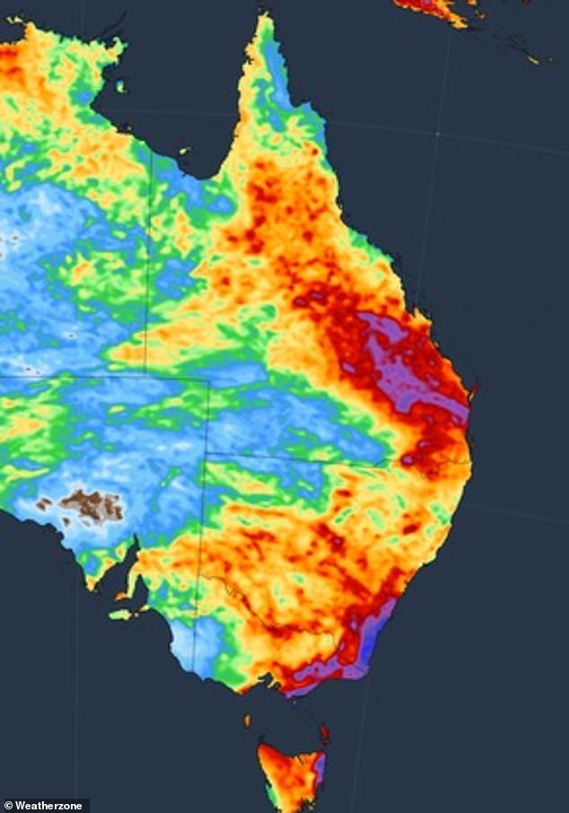
The east coast of Australia will be lashed by heavy rain this week. The photo shows the total amount of precipitation expected by Sunday

Above, a Weather Zone chart shows the areas expected to be affected by the most significant rainfall in red and purple, in the most extreme case. Blue and green represent lighter rainfall
Brisbane residents can also expect rain, with between 2mm and 20mm forecast for Tuesday, with storms also possible on Wednesday.
The Sunshine State will be clear on Thursday, with sunny conditions and temperatures in the low 30s expected for the remainder of the week.
In south-west NSW, a severe thunderstorm warning has been issued for Wentworth and Menindee, with damaging winds also likely to cause major damage.
The dire conditions come despite Australia having declared an El Niño – a climate pattern that typically produces below-average rainfall and higher-than-average daily temperatures.

Sydney, Melbourne, Canberra and Brisbane are all in the line of fire due to extremely wet conditions throughout Tuesday and Wednesday
While September and October were very dry months for Australia, some states experienced their wettest November on record this year during El Niño.
“Some areas in Queensland, NSW, the NT, SA and WA have already received more than three times the average November rainfall and more wet weather is in store for the final days of the month,” Weather zoneBen Domensino said.
The meteorologist said the reason for the wet conditions is because El Niño is not the only factor affecting Australia’s weather.
Mr Domensino said individual weather systems are controlled by jet streams of very fast-moving air.

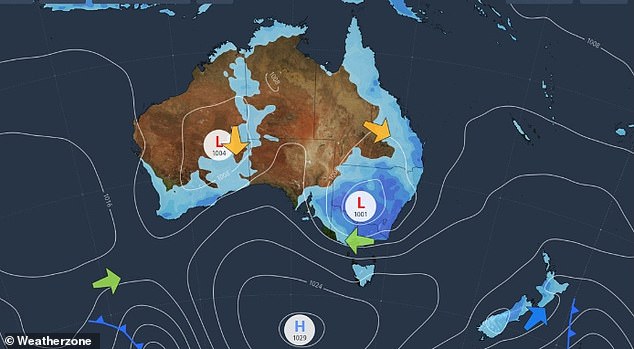
While September and October were very dry months for Australia, some states experienced their wettest November on record this year during El Niño (weather forecast pictured for Wednesday)
‘There are two jet streams in each hemisphere, usually flowing from west to east. The strength and shape of the jet streams influence the movement of high- and low-pressure systems near the Earth’s surface,” he said.
He said a “meridional jet stream” remained over Australia, causing unfavorable weather for an extended period.
That jet stream “will produce a prolonged period of rain and thunderstorms this week” over eastern and southeastern Australia.
Adelaide was battered by storms on Monday evening, causing some flight delays and leaving thousands without power.
By 9am on Tuesday, more than 33mm had been recorded in the CBD and 35.8mm at Adelaide Airport.
Tuesday was the wettest November day in 59 years at the airport, and in the CBD this month was the wettest day in 18 years.
The SES responded to 170 calls for help across South Australia by 9am on Tuesday.
Severe thunderstorm warnings remain in effect around Adelaide on Tuesday.
Meanwhile, those living in Perth on the other side of the country can expect a dry and sunny week with highs of 33 degrees on Friday.
Hobart will see some cold temperatures with highs of 17 degrees Celsius for Wednesday and Thursday, with rain also possible on these days.
Darwin will hover around the low 30s, with storms also on the horizon.
