More than 230 million Americans will reach above-average temperatures before a chill occurs in most of the country
The weather in the United States will see drastic changes this week as above-average temperatures are forecast in cities from Arizona to New York in the coming days before cold air brings back the winter feeling.
More than 235 million Americans will experience temperatures on Tuesday that are 5 to 20 degrees higher than average in early November FOX Weather.
That’s an extreme change from last week’s record snowfall in the Rocky Mountains, Great Lakes and New England.
According to The Weather Channelan upper-level zonal pattern, which when weather systems move parallel to the latitude lines, will keep temperatures mild through the start of the week.
The warm weather will begin in the Southwest and spread eastward into Texas and the Southern Plains.
According to The Weather Channel, an upper-level zonal pattern, which is when weather systems move parallel to latitude lines, will keep temperatures mild through the start of the week.
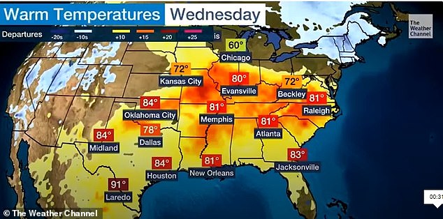
Texas and the Southern Plains can expect highs in the mid to upper 80s, while the Mississippi and Tennessee valleys and the Gulf Coast will remain in the low 80s.
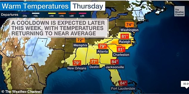
Cold air will move down from the west, bringing temperatures back to average levels by the end of the week
These areas can expect highs in the mid 80s, while the Mississippi and Tennessee valleys, as well as the Gulf Coast, will remain around 80 degrees.
Cities in the South, such as Nashville and Chattanooga, Tennessee, and Huntsville, Alabama, could have record days with temperatures in the 80s.
Cold air will move down from the west, bringing temperatures back to average levels by the end of the week.
St. Louis is expected to experience a high of 83 degrees on Wednesday and drop to 61 degrees on Thursday, it is reported CNN meteorologist Allison Chinchar.
Denver is expected to see high temperatures of 75 degrees on Tuesday and reach a projected high of 48 degrees on Thursday with a chance of snow.
Abrupt temperature fluctuations are common in Denver and the eastern slopes of the Rocky Mountains AccuWeather.
Warm air and dry conditions are expected to move through the air from the west and southwest through Tuesday.
Wednesday through Thursday, winds in the Mile High City are forecast to shift to the east or northeast and air will rise and cool, dropping temperatures by 20-40 degrees in a few hours or less.
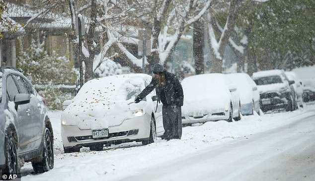
A motorist clears snow from a vehicle in Denver after a foot of snow fell on October 29. Areas from the Rockies to Chicago were covered in snow last week
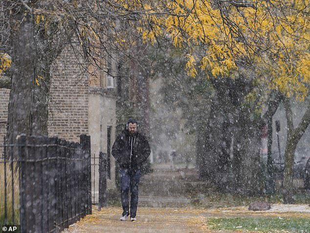
Chicago faced an inch of snow on Halloween day. During last week’s record snowfall, temperatures in the Lower 48 states averaged 31.3 degrees, more than 10 degrees below average
In Arizona, temperatures in Phoenix are expected to remain above normal through Wednesday, according to the National Weather Service.
“We’re expecting fairly calm conditions … but (Monday) will be quite hot and we’ll be quite close to record high temperatures,” meteorologist Matthew Hirsch told The Arizona Republic.
The Arizona record set on November 6 is 94 degrees, set in 2007. Hirsch said there was a 50 percent chance of tying that record.
It’s a dramatic change from last week, when 17.9 percent of the contiguous United States had snow, according to the National Oceanic and Atmospheric Administration.
The temperature in the Lower 48 states averaged 31.3 degrees, more than 10 degrees below average.
Cities in Texas, Oklahoma, Kansas and Missouri broke record lows. This included a glacier temperature of 8 degrees at Mount LeConte, Tennessee – the first single-digit low ever at the location.
El Niño will hit the world hard this year, causing a drastic change in weather conditions compared to the average.
NOAA has published maps showing how much snow you can expect in your state this winter based on average snowfall in recent years – with record amounts of snow expected in the coming months.
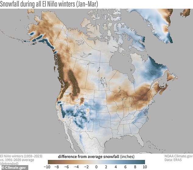
Snowfall during all El Niño winters (January-March) compared to the 1991-2020 average – with blue colors showing more snow than average and brown less snow than average
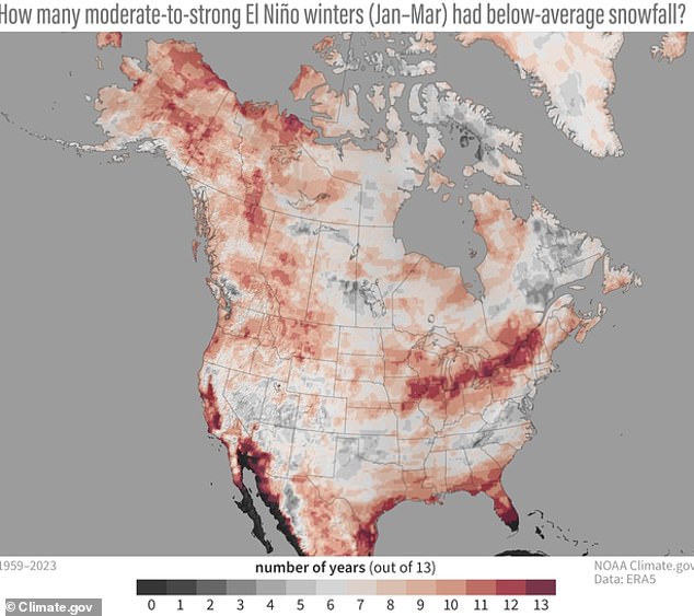
The above map from NOAA shows the number of years with below-average snowfall during the 13 moderate to strong El Niño winters that have occurred since 1959
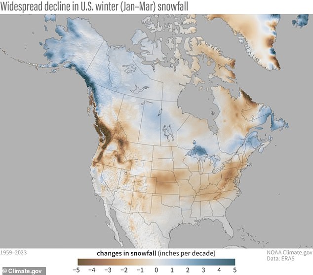
A third NOAA map showed changes in snowfall (in inches per decade) between 1959 and 2023 in the US – and indicated that snowfall has decreased overall
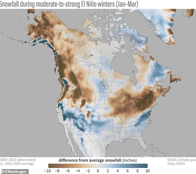
This NOAA map detailed how each area deviated from the average snowfall – with blue indicating more snow and brown indicating less snow.
During stronger El Niño winters, more snow falls than average in the US Midwest and western states such as Colorado, New Mexico, Arizona and Utah.
New England is seeing much less snow than normal during the intense El Niño seasons – New York, Vermont and parts of Maine are likely to see much less snowfall this winter than the 1991-2020 average.
El Niño is caused by a shift in the distribution of warm water in the Pacific Ocean around the equator.
This change in air and ocean currents around the equator can have a major impact on weather patterns around the world by creating pressure anomalies in the atmosphere.
