Hurricane Lee update: East coast on edge with storm set to strengthen again to category four – bringing monster waves and lethal riptides as early as this weekend even if coastline is spared direct hit
Hurricane Lee will strengthen again this weekend to category four, with monster waves and deadly tides, even if the coastline is spared a direct hit.
Forecasters say the storm, once a Category 5 but downgraded to a Category 3 on Saturday, continues to produce dangerous winds of 110 miles per hour and gusts of 140, creating dangerous conditions as it charts a new course and gains strength.
Experts predict the storm will strengthen over the next 24 to 48 hours as it moves into more favorable climates, which could make the storm a Category 4 that will hit sometime on Tuesday, The Weather Channel reported.
Late Saturday afternoon, the storm was about 350 miles east-northeast of the northern Leeward Islands and moving west-northwest.
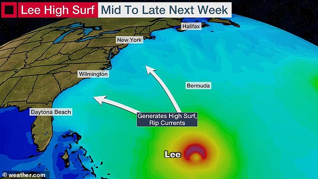
From Sunday through Monday, Lee is expected to produce rip currents and large waves along most of the East Coast that will worsen as the week progresses, CNN reported.
Forecasters also predict that Tropical Storm Margot could turn into another hurricane, but it is not expected to make landfall. The storm that has formed in the North Atlantic Ocean is expected to reach wind speeds of more than 120 km per hour this weekend.
Hurricane Lee was a Category 5 storm with winds of up to 160 mph

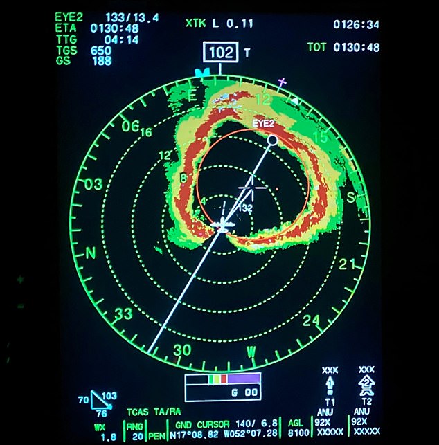
Radar showing the path of the storm
“Lee is moving west-northwest at 12 mph (20 km/h) and this motion is expected to continue early next week, with a significant decrease in forward speed beginning later today and Sunday,” the hurricane center reported.
Hazardous beach conditions are expected to develop around the western Atlantic Ocean in the coming week, the news outlet reported.
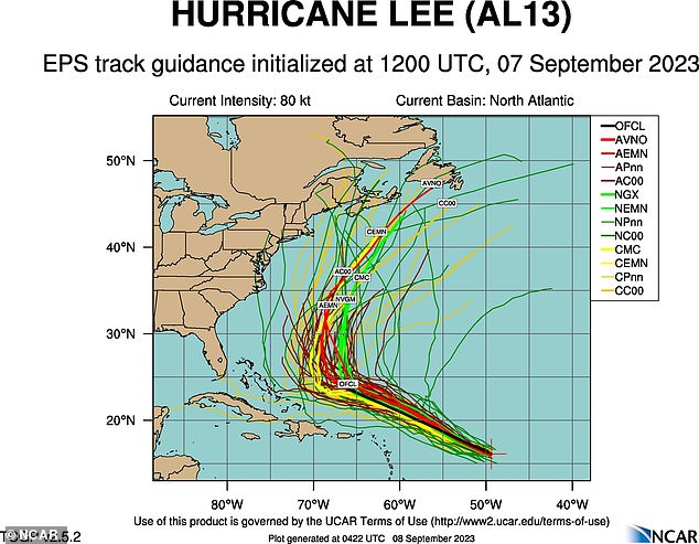
The Weather Channel reported that the storm was moving between Bermuda and North Carolina and parts of Maine. While another storm model showed Hurricane Lee’s track between Bermuda and the US strengthening.
The hurricane center said it is too early to determine whether the storm’s core will have direct impacts on the U.S. mainland.
The Hurricane Center said Tropical Storm Margot is currently located 750 kilometers west-northwest of the Cape Verde Islands and moving west to northwest at a speed of 26 kilometers per hour.
Weather experts say Margot currently poses no threat to any land and is expected to remain over the ocean.
Hurricane Lee quickly grew into a monstrous Category 5 hurricane Thursday through Friday morning, taking the title of the strongest hurricane to hit the Atlantic Ocean during the 2023 season, according to AccuWeather.
The weather service said the hurricane will turn north of the Caribbean this weekend before making a northerly turn along the east coast of the United States next week.
While meteorologists warn that the threat of impacts is increasing in New England, much of the East Coast will see heavy seas and dangerous surf.
Lee has already traveled more than 1,000 miles (1,600 kilometers) since originating over the west-central Atlantic Ocean early last week, AccuWeather reported.
Early next week that distance will probably more than double.
This weekend, Hurricane Lee is expected to follow a curved path around a large high-pressure area over the central Atlantic Ocean, which experts predict will guide the megastorm north of the Caribbean’s northern islands.
The colossal storm will then move to the northeast of the Bahamas, west of Bermuda and east of the southeastern United States during the first half of next week.
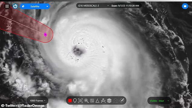
Stunning images have revealed the thundering eye of Hurricane Lee as it barrels towards the east coast, threatening to leave a trail of chaos in its wake after escalating from a Category 1 to a Category 5 hurricane overnight.

The image shows Hurricane Lee over the Caribbean on Thursday, the first Category 5 storm of the season

Forecasters have struggled to determine the exact path and strength of Hurricane Lee, leading to varying estimates about the extent of damage it could cause.

Hurricane Hunters posts a clip of Hurricane Lee on September 8, 2023. The caption read: ‘here is last night’s flight into the Category 5 eye

Hurricane Lee is barreling towards the East Coast and is expected to make landfall next week after severe weather hit the region on Friday evening
The Air Force’s ‘Hurricane Hunters’, a weather reconnaissance squadron, delivered brutal lightning strikes that lit up the twister in a breathtaking way. social media message on Friday.
Hurricane Lee has been churning across the Atlantic Ocean for days as it gathers steam, but forecasters are struggling to determine its path and the hurricane is not expected to make landfall until late next week.
As the East Coast braces for an impact, New York City and Boston got an early taste of the potential devastation when the hurricane’s currents produced severe storms Friday evening.
The Big Apple was hit by thunder and lightning, as well as clouds that some locals found “spooky,” while further up the coast in Massachusetts, trees and power lines were felled by high winds.
Hurricane Lee was registered as a Category 1 hurricane on Wednesday after forming near the Leeward Islands in the Caribbean.
Forecasters quickly warned it had devastating potential, and shocking satellite projections showed it gaining speed and strength on Thursday, reaching speeds of more than 160 mph.
Earlier in the day, the storm recorded speeds of about 80 mph (130 km/h) and after circling over the Atlantic Ocean, waves reached more than 55 feet (17.5 meters) near the center, the National Hurricane Center found.
One reason for the escalation is unusually warm waters over the Atlantic Ocean, which have registered nearly 86 degrees Fahrenheit in their path and which meteorologists say are more similar to temperatures in the Gulf of Mexico than the Atlantic Ocean.
As of Friday evening, Lee remained well off the U.S. coastline and was about 450 miles (700 kilometers) east of the Leeward Islands, moving northwest at 13 mph (21 km/h), according to the New York Times.
As it spirals well to the southeast of its potential landfall, meteorologist and hurricane expert Michael Lowry warned that it has features that could cause significant damage.
He said on X (formerly Twitter) that ‘Lee is the farthest southeast we have ever observed a Category 5 hurricane in the Atlantic Ocean since records began 172 years ago.
